Presentation of the model
Writen by Hanieh Sayedhashemi in her PHD, readable here (Chapter 4, p85)
The EROS semi-distributed hydrological model simulates daily discharge (Thiéry, 1988; Thiéry and Moutzopoulos, 1995; Thiéry, 2018). This model is made up of a network of sub-basins in which each sub-basin is subjected to rainfall, snowfall and potential evapotranspiration. The water balance in the sub-basin is modeled by a lumped model using three reservoirs as follows:
the first reservoir represents the soil that is subjected to evapotranspiration and precipitation;
the second non-linear reservoir represents the vadose zone, models the percolation time, and determines the partition between runoff and infiltration;
the third reservoir represents the underlying aquifer characterized by a recession time, and characterizes the groundwater flow.
The contribution flow of each sub-basin is the sum of the runoff and the groundwater flow. The total flow at the outlet of each sub-basin is the sum of its contribution and the total flow of the upstream sub-basins (delayed by a transfer function representing their propagation time).
Water abstractions, dams and ponds are not considered in the EROS model, and the hydrometeorological balance in each sub-basin is carried out at a daily time step. This hydrological model was already used in several studies on the impacts of climate change (Ducharne et al., 2011; Moatar et al., 2013; Habets et al., 2013; Bustillo et al., 2014).
The EROS hydrological model uses Ta (°C), solid and liquid precipitation (mm), and reference evapotranspiration (ET0, mm) to produce daily Q and groundwater flows over the Loire River basin (Thiéry, 1988; Thiéry and Moutzopoulos, 1995). Meteorological inputs are provided by the SAFRAN atmospheric reanalysis data (Vidal et al., 2010). ET0 is computed from the SAFRAN variables with the Penman-Monteith equation (Allen et al., 1998).
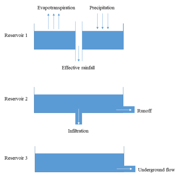
Schematic figure of the EROS model operation for each sub-basin